

PARK NEWS
A small section of the Southside Loop remains closed. The trail map can be found here.


A small section of the Southside Loop remains closed. The trail map can be found here.
Standard Time Hours : 7am- 6pm, daily; extended to 8pm on Fri; Daylight Savings Time Hours: 7am -9pm, daily
11am -noon & 4-5pm, daily
$3 adults; $1.50 SC seniors; $1 children age 6-15; age 5 & younger free
Pets are allowed in most outdoor areas provided they are kept under physical restraint or on a leash not longer than six feet. Owners will be asked to remove noisy or dangerous pets or pets that threaten or harass wildlife.

The trails listed below are the most traveled trails located at the park. These trails are the park’s most famous trails within the 50 mile trail system.
Click here for a downloadable trail map and information.
Length: 12.6 miles
Type: Hiking, Mountain Biking, Equestrian
Difficulty: Moderate
The Palmetto Trail, through historic Croft State Park, connects the city of Spartanburg to the Glenn Springs area in southern Spartanburg County. The 12.6-mile trail is open to all user groups but is only open to horses and bikers in designated areas. This trail enters Croft at the Glenn Springs Passage trailhead and follows ridges, crosses brooks, and hugs portions of Kelsey Creek to the historic Cedar Springs area. As one travels down the trail they will encounter remains of old homesteads, many beautiful and varying wildlife habitats, and mixed forests. This is a beautiful trail for all users that you will definitely want to travel.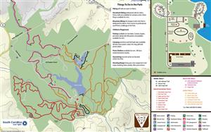
Length: 1.5 miles
Type: Hiking
Difficulty: Easy
This easy, foot-traffic-only 1.5 mile loop trail begins from the dirt road that leads to the stables and continues on through varying wildlife habitats. You will descend through mixed pine and hardwood trees, wind along the rocky shoals of Fairforest Creek giving a sense of a mountain trail, and then loop back uphill through the woods. Remains of an old mill site along Fairforest Creek and bridge crossing are two historical points of view along this trail. Trail signs at intersections will help you find your way back. You may see a variety of wildlife including birds, deer, squirrels, and snakes.
Length: 6.5 miles
Type: Equestrian and Hiking
Difficulty: Moderate due to length
From the stable area, at the fourth trailhead off the gravel road you will find the Foster Mill Trail. It is open to both horseback riding and hikers. The Foster Mill Trail travels along much of an old road bed and has portions of singlewide and doublewide trail making it the widest trail at Croft; perfect for both equestrian and hiking beginners. Along the trail, you will stroll through some historical areas where you will see old trestle bridges as well as old cemetery sites. This trail will take you along ridges, crossover beautiful Kelsey Creek and take you right along the shore of Lake Craig. If you travel this trail you will find yourself in the beautiful bounty of historical, cultural, and natural resources that make Croft State Park.
Length: 9.7 miles
Type: Mountain Biking and Hiking
Difficulty: Moderate to Strenuous
Southside Loop is the longest trail on the park, traveling through rolling terrain, hills and along creek sides. It offers access to many other mountain bike and hiking trails in this extensive trail system totaling over 16 miles of trails. In the lower elevations, the trail winds along Fairforest Creek and trail users can view huge hardwoods growing in the moist environment. As trail users gain elevation away from Fairforest Creek massive white oaks can be seen throughout the woods. Southside Loop can be accessed either crossing the “Advanced America” bridge on the Palmetto Trail or from the Southside Parking lot at the end of Groce Rd. This trail’s degree of difficulty is considered moderate to strenuous due to the length and varying technical terrain.
Length: Rocky Ridge 3.4 miles, Whitestone Springs Spur (one way) ¾ mile
Type: Equestrian and Hiking
Difficulty: Moderate
Rocky Ridge bears off of Foster Mill just past the Kelsey Creek Bridge crossing and is open to both horseback riders and hikers. The trail offers several scenic passages through hardwood forest and mixed pine trees. It offers the trail user a beautiful view of rolling hills and creeks as it makes it way to past the historic Whitestone Springs Spur Trail. This spur trail offers a one way route to the historic location of Whitestone Springs. Trail users venturing to this location can view the spring and see evidence of the bottling business, several foundations, and the foundation of the 4 story hotel from the late 1800’s. This trail is a must if you really want to immerse yourself in the rich history and tranquil beauty that make Croft State Park so special.
Flat Pass – Mileage: 0.5 mile Difficultly: Easy
High and Dry – Mileage: 1 mile Difficultly: Moderate
Rock Creek Trail – Mileage: 1 mile Difficultly: Moderate
Centerline Trail – Mileage: 1 mile Difficultly: Moderate
Lizard Trail – Mileage: 1 mile Difficultly: Moderate
Outlaw Trail – Mileage: 0.5 mile Difficultly: Easy
Idaho Trail – Mileage: 0.5 mile Difficultly: Very Strenuous
Fern Gully Trail – Mileage: 1 mile Difficultly: Easy
Beech Tree Trail – Mileage: 2 miles Difficultly: Moderate
Fairforest Creek Trail – Mileage: 3.5 miles Difficultly: Moderate
Lake Johnson Loop – Mileage: 2.4 miles Difficultly: Easy
Hiking Only:
Lake Johnson Trail – Mileage: 2 miles Difficultly: Easy
Lake Craig Trail – Mileage: 0.75 mile Difficultly: Easy
Lake Johnson Fairforest Creek Connector – Mileage: 4.5 miles Difficultly: Moderate to Strenuous
Craig Trail – Mileage: 1 mile Difficultly: Easy
Use #SCStateParks and your content could be featured here! You can also upload your photos for us to use across South Carolina State Parks' Marketing by using the Public Uploader and agreeing to the Terms & Conditions.

